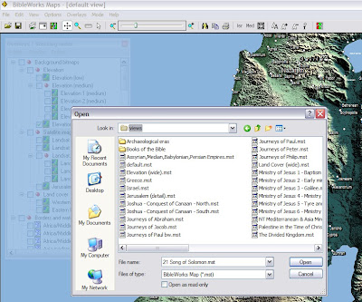
A new BW7 classroom tip was recently posted on "Using the BW Maps Module." It provides a concise and helpful overview of this module. (Do note that there is another map module in BW7 that uses the NET Bible maps. Resources > Maps > NET Bible Maps.) I'm working on a more complete review of the BW7 map module, but here are some additional, quick observations:
- It is a very nice mapping program, and it is not too slow. Zooming and panning while using the Satellite Imagery overlay is the slowest. Having used GoogleEarth, I do miss the perspective panning, however. I do also appreciate the ability to use Options > Adjust Color Balance (or click on the red/green/gray icon in menu bar) and work with the colors, including turning it into a grayscale image. It is great to be able to choose between backgrounds: elevation, satellite, land cover.
- One needs to become familiar working with the Overlays/Stacking Order window. I prefer to keep the window open, but then choose Option > Make this window transparent. Keeps it handy but out of the way. (Cf. my graphic above.)
- Note that you can find sites within the map module using Edit > Find or by clicking on the binoculars in the menu bar. Also note that if you are reading a text in BW7, right-clicking on a place name will give the option of "Lookup in BibleWorks Maps." Choosing this will open the map module and let one choose the site.
- Sometime labels seem too big or off the map. I think it must be an issue with zoom and/or chosen overlay.
- Sites can be chosen related to a particular book of the Bible or event or era. One can use the Overlay window menu to toggle on/off sites, but it is perhaps easier and faster to open one of the predefined maps. (Cf. file selection window on graphic above.)
- It is very nice to be able to edit maps and create new overlays and/or sites.
- Note that hovering over a site will give you some information about that site: location, spelling in various versions, etc. Right-clicking on a site will give you its name in some English versions, and clicking on one of those conducts a search returning all the hits back in the base program.
- The program does not interact with a mouse's scroll wheel (which I usually like to use for zooming).
- There is no link between a site and the dictionaries in BW7. (You have to right click on site, click on a version to conduct a search, return to the main program, right click on the site name in the text, and select Lookup in Default Bible dictionary. That said, ISBE, Faussett, and Easton are not the greatest of dictionaries.)
- Another nice feature is the Edit > Copy as vectors/bitmaps feature that allows for defining a rectangular area.
- The map module does not provide the kind of maps that shows, for example, the general locations of the twelve tribes after the conquest shaded in various colors (but there is a "Division of Canaan" map with labels) or the divided kingdom (but see the "Divided Kingdom" map which does have the regions outlined).
- One important element I really miss is the lack of any way to display the ancient roads. This is one feature where even the free to use, unregistered version of the Bible Mapper program is really helpful. (I also think that the maps in Bible Mapper are visually more attractive and clearer in their presentation of geographical information.)


Thanks for this useful overview, I must explore BW maps! Please note though that Bible Mapper is shareware rather then "free".
ReplyDeleteThanks, Tim. I edited the entry to indicate that there is a free-to-use, unregistered version of Bible Mapper. (The site does say, "You may download and use Bible Mapper completely free of charge.") The registered version, however, includes a number of extra features and maps and costs US$35.
ReplyDelete