Showing posts sorted by relevance for query "bible mapper". Sort by date Show all posts

Tuesday, May 5, 2015

Bible Mapper 5 released!

 I am happy to report that David P. Barrett has released a version 5 of his excellent Bible Mapper program. Barrett provided the maps for the Crossway ESV Bible Atlas which is the required atlas I use in my Survey of the Lands of the Bible class. From the description on the site:
Bible Mapper is the ideal tool for researching and creating maps of the biblical world. Virtually every known location and geographic feature in the Bible can be displayed and fully customized quickly and easily, making it a snap to create stunning maps adapted to your particular needs. Check out the gallery of pre-made maps that ship with Bible Mapper 5.

You can learn about all the features of this Windows program HERE. Notable new features include the capability to:
  • Create high resolution maps of Jerusalem (the Jerusalem Ordnance map of 1865 is also able to be overlaid on the terrain)
  • Upload your custom objects or styles to a repository to share with other registered users, or restrict access to yourself for easy import into other maps
  • Import basic KMZ/KML data (points, lines, areas, etc.) created by other software (e.g., Google Earth) and customize it on your map
If you want to get an idea of how the program works, you can use version 3 for free with no limitations. A key for the new version 5 costs $37. Here are examples of two maps I created using Bible Mapper.

One of the great benefits of this program is that any map you create is your own, and you don't need to obtain any copyright permissions or pay any costs to share your map. You simply need to cite Bible Mapper as the tool you used. A great example of how Bible Mapper has been utilized is at BibleAtlas.org where there are maps of every biblical location.


Wednesday, November 18, 2009

Bible Mapper 4 Released!

Bible Mapper 4 is now available! This is not only an outstanding program but one of only a few programs that allows for full user customization of biblical maps. Furthermore, David has a heart for ministry, and this program has been a great way for Bible translation teams to produce maps that do not have any copyright restrictions. (BTW, this is a big deal.) Cost for the license key is $37.

Back in April of 2008, I reported that the Bible Mapper 3 program had been withdrawn but was subsequently shared for free but without any support or promise of further development. Bible Mapper 3 is still available for free, but it lacks the improved software and will not have any technical support. Bible Mapper 4 also includes
35 pre-made maps (as map templates) from the Bible Mapper Atlas Collection. It can read BM3 files, but BM4 files cannot be read in BM3. David also has indicated to me that:

I've also made a number of improvements and bug fixes to the program (including a much faster/smoother Select Object engine). One of the new features is the inclusion of Palestine Grid 1923 coordinates, which are often used in older academic works. You can't input data based on these coordinates, but you can opt to use this coordinate format in the status bar regarding the cursor location.
I am very happy with the improved Select Object tool, and the Palestine Grid coordinates is a feature that only Accordance's Bible Atlas also offers.

With David's blessing, I set up a Bible Mapper wiki for mutual user support. Some video tutorials were posted and a number of maps are shared on the site. Users of BM3 and BM4 are encouraged to join this wiki.

For a survey of digital resources for biblical mapping, see the resources I've assembled here.

Thursday, June 8, 2017

Bible Mapper Video Tutorials

Bible Mapper 5 remains the only Bible mapping program with which I am familiar that allows users to create their own, copyright free, high-resolution maps. As David P. Barrett, author of the program and also of the maps in the excellent Crossway ESV Bible Atlas, notes:
Bible Mapper is the ideal tool for researching and creating maps of the biblical world. Virtually every known location and geographic feature in the Bible can be displayed and fully customized quickly and easily, making it a snap to create stunning maps adapted to your particular needs.
Version 3 is free to download and is fully functional. To get the improvements in version 5, the cost is $37, though you can download and try it for free (just not save any maps you create).

Some time ago I made some introductory video tutorials, but it was back in the day of WMV files. It was pointed out to me that those don't play well on a Mac, so I've just uploaded them all to YouTube. There are 7 short videos in all you can check out here:
Bible Mapper YouTube Video Tutorials Playlist

If you do purchase Bible Mapper 5, Barrett does provide email support, but you may also want to check out the user wiki I created here.

Friday, May 2, 2008

Bible Mapper wiki update - More videos!

Want to learn how to make the fine map pictured below that depicts Paul's travels as described in Acts 16.11-12? I made it using the free Bible Mapper program. Over on the Bible Mapper wiki, I have posted a series of short videos showing all the necessary steps. Look for them on the Tutorials page. Okay, I have other things to do, so that will be the last of my work on Bible Mapper for a while. Join the wiki, and share your work!
And BTW... did you note the new RefTagger from Logos? Hover over this Acts 16.11-12 reference for a moment.

Wednesday, February 1, 2017

New Bible Mapper WebViewer!

Web page view showing results of a search for sites in John 2
David P. Barrett, creator of the Bible Mapper program and co-author of the Crossway ESV Bible Atlas, has just released an initial version of the Bible Mapper WebViewer. According to Barrett,
It is intended to be a quick reference tool for Bible geography information, not a way to make maps (there is not a way to save, export, or print a map other than the default tools of your browser). I envision people using it to look up Bible geographical information on the fly, such as on their mobile device at church or Bible study, or on their computer while studying a passage. You can also input a reference like "Joshua 10-12," or pass in a page URL, and it will automatically fetch the text and map all the locations it can discern on it (though it's definitely not 100%).
There are still some glitches in my intial testing. It works well in Chrome on my Android phone and on my desktop computer, but it got hung up in Firefox on my desktop. The interface is very nice and works well on my phone, but zooming in/out requires repeated taps of the + and - icons. Searching for a specific site works very well. Searching for sites mentioned in a specific passage or sites mentioned on a web page works but is not entirely reliable. Including the option to display hi-res tiles did not particularly slow things down, and it's nice to be toggle on/off OT and NT roads. (If you're looking for something more in-depth, check out the Bible geocoding at OpenBible.info.)

Especially for its purpose as an quick reference, particularly for mobile devices, this is a very nice tool, and it's even better that Barrett is providing it for free. Thanks, David Barrett!

Wednesday, April 25, 2007

Of the making of maps there is no end...

By now any of you who have been reading this from the start have become overwhelmed with all the map resources I've pointed out, so, in addition to adding a few more, let me try to organize what I've found. Note that I am focusing on stuff you can get on the Internet (so I'm not really mentioning any hardcopy atlases) and almost all the stuff I'm highlighting is free.

  • Maps for use in Logos, BibleWorks7, and Accordance:
    Each of these programs comes with collections of maps, but there are addin maps you can you use to enhance them.

    • Go to this post to obtain an addin using data from OpenBible.info to download a Bible Geocoding addin for BibleWorks.
    • Go to this post to obtain addins from Nelson Ministry Services and the Access Foundation for Logos.
    • [UPDATE 2007.09.04] Accordance offers a Bible Atlas CD for $89 that includes their Bible Atlas program. Here is a helpful article detailing the use of the program.
  • Programs or websites that feature maps or mapping:
    These are computer programs that feature mapping

    • GoogleEarth: This remarkable program has generated interest in creating a variety of Biblical mapping mashups. This post shows you how to get started with GoogleEarth and how to create your own locations and do geocoding of pictures.
    • In this post which you should check out first after getting GoogleEarth on your computer, I show you how to get biblically oriented overlays and collections of links to use with GoogleEarth. In this post, I show you how to make your own overlays using maps.
    • Interactive Satellite Map of the Holy Land: It is kind of like using GoogleEarth with biblical sites overlays. Like GoogleEarth it is free and uses excellent satellite maps, but unlike GoogleEarth: a) it is downloadable, so you don't need to be online to use it; b) it runs in a browser window; c) it is dedicated to biblical sites and has a very nice interface to quickly locate sites; and d) you can also download a version that can be used on a PocketPC.
    • (Update 2007.07.19) Speaking of PocketPC (and also PalmOS), Olive Tree offers a Bible Map Atlas for $21.
    • I can recommend HolyLand 3-D which comes with the HolyLand Satellite Atlas Volume 1 for $70. This program allows for some fascinating flyovers that I really like. Resolution of images and terrain mapping is superior to GoogleEarth, and it is dedicated to biblical sites and includes photos, information, and scripture links.
    • Bible Mapper: As they say, it "is a fully interactive, highly accurate Bible mapping system that helps you quickly and easily create customized maps of the Holy Lands or study a particular period and aspect of Bible history." The free, downloadable version is quite helpful and does a nice job of providing period-specific views including boundaries and roads. (To see ancient roadways, this really provides some of the most helpful maps.) It is possible to click on a location on the map to open up the satellite maps in GoogleMaps. To get high resolution relief maps within the program there is an additional cost of $35.
    • BibleMap.org: This is another application of the GoogleEarth data to biblical sites that is strictly an online site. Basically you start with a biblical text (using ESV or KJV), and for sites mentioned in the text, links are then provided to GoogleMaps. Once the site is pinpointed on the map, clicking on it brings up information from the 1913 ISBE. It works fairly well to accompany the reading of a text, but it isn't designed to find a place apart from the text. One thing that is nice is that by using GoogleMaps, you have the option of choosing Map / Satellite / Hybrid view which can sometimes be helpful. (Program is in beta now.)
  • Biblically oriented programs or sites that include maps
    • In this post, I described the free, downloadable programs e-Sword and the Online Bible which include maps. I also describe the online and downloadable NET and upgraded NeXt Bibles and the fine maps they include.
    • (2007.07.16 update) The Virtual World Project: Focuses on the ancient eastern Mediterranean with resources for Greece, Turkey, Israel, and Jordan. Search by map location, features (e.g., churches, synagogues, temples), or periods (Paleolithic through Crusader). Excellent collection of notes and pictures, including many 360 degree views.
    • (2007.07.17 update) The Geography and the Bible page at Bible-History.com has a large collection of maps. Especially note the Clickable Map of Ancient Israel of the 1st century CE.
    • Stephen Langfur has been putting together an excellent study resource for biblical sites connected with the Near East Tourist Agency. The maps on that page will get you started.
    • Walking in Their Sandals looks to be a great Bible study resource that includes maps and location information and pictures. Cost: $30.
    • iLumina Gold includes the Tyndale Handbook of Bible Charts and Maps along with over 200 interactive charts and maps and 1000 Holyland photos. Cost: ~$65.
  • Standalone maps
    These are links to sites with actual maps. If you don't have one of the programs cited above and just want a particular biblical map, check out these sites. Remember to use them with proper attribution and copyright observations.

    • NT Gateway Listing of Maps: This is Mark Goodacre's extensive list of links to map sites, most of which are simply collections of maps.
    • Bible Maps and Pictures: Another collection of links to online maps.Especially note the site's own Bible Maps with very helpful 'topical' maps (i.e., maps reflecting a particular event, period, or person).
    • (2007.07.17 update) For visual clarity, I really like the 173 maps provided by the Access Foundation. They are all available online on the Bible Maps page of StudyLight.org. They can be viewed in a variety of sizes. (In a previous post, I noted how these maps are available for download and integration within Logos.)
    • (2007.07.17 update) The American Bible Society has some very useful maps on their Interactive Maps page. (I could not get the interactive feature to work very well in IE and not at all using FireFox, but the standard maps work fine.) These are the maps that are part of ABS's The Learning Bible available both as a book or CD. (As noted in a previous post, these maps are also available within the eSword program.)
    • Some links to maps associated with Jerusalem that I did not see on either of the preceding lists are found HERE about 2/3 of the way down the page.
    • Another collection of maps is available at the Jewish Virtual Library HERE.
    • (2007.05.24 update) Just found another collection of maps, mostly from 15th-early 20th century of the Holy Land HERE. (The site is part of the Jewish National and University Library. I found the link on Rick Brannan's Supakoo site.)
    • (2007.07.16 update) Yet another site: Maps of the Middle East - Most are biblically related maps with some comments.

Monday, April 21, 2008

Bible Mapper wiki

I have recommended and discussed the Bible Mapper program in the past. It is a fine mapping program, and it is free to use. What's more, it can be used to create copyright free maps. The program is provided without support, however. For this reason, I have created a Bible Mapper wiki for users to provide mutual support and advice. Perhaps of even greater help, it can serve as a repository for sharing maps and templates users have created. Check it out and download maps of "The Seven Churches of Revelation" that I have created and see how you can also participate on the wiki.

Thursday, April 10, 2008

More on Bible Mapper and other mapping resources

It is always worth checking out what Todd Bolen is doing over at BiblePlaces.com, and it may be worth it to you to subscribe to his every-other-month newsletter. In his latest newsletter, there is some great stuff on Corinth including a PowerPoint you can download and use that uses satellite imagery annotated with the archaeological features.
Todd also gives a nice example of how he uses Bible Mapper to make maps like this one of Turkey. (Here is an earlier posting I made re: Bible Mapper.)
Through a link from BiblePlaces, I also found this incredible listing of mapping resources: Map Sources/GeoHack. If you are interested in mapping, this collection of links will get you to everywhere else on the web. One site I checked and particularly liked is Maps-For-Free. It is not designed for searching for sites, but, in addition to the usual Google satellite imagery, it has some excellent terrain maps (Todd's map shown above is an example of a terrain map) and relief maps (such as the one shown below). Have fun playing around with the various layers and other map types.

Wednesday, April 30, 2008

Bible Mapper wiki update

With some help from the creator of Bible Mapper, David Barrett, and from Tim Bulkeley, the Bible Mapper wiki has been updated. I have added two short videos in the Tutorials section that should get you going on how to use the program.

Wednesday, January 6, 2010

2009 Review of Biblical Studies and Tech Tools


Tech stuff is moving so quickly, but it is helpful to review and get a bit of perspective on what's happened over the past year in the area of biblical studies.
I'm sure I missed something important that happened in 2009, so leave a comment!


On a more personal level, I'm still trying to figure out the future of seminary education (here and here) and, in particular, its relation to technological resources. 
I am also finding that it is very hard work trying to keep up with all the developments as well as simply keeping up with blogging. A move in August kept me from blogging that month, and a publishing commitment kept me from doing anything in December. Even compiling this year end review means I'm procrastinating on another project I need to do... No new year's resolutions in this area, but I am still committed to keeping this thing going. I'll probably have to narrow my focus a bit, but I believe that this kind of blog does provide a worthwhile contribution to the field of biblical studies.
Now, when I get some time, I hope to give some predictions about 2010!

Thursday, December 6, 2007

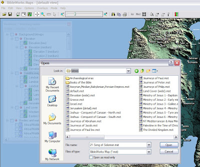
BibleWorks Classroom Tip 1.9 - Maps Module


A new BW7 classroom tip was recently posted on "Using the BW Maps Module." It provides a concise and helpful overview of this module. (Do note that there is another map module in BW7 that uses the NET Bible maps. Resources > Maps > NET Bible Maps.) I'm working on a more complete review of the BW7 map module, but here are some additional, quick observations:

  • It is a very nice mapping program, and it is not too slow. Zooming and panning while using the Satellite Imagery overlay is the slowest. Having used GoogleEarth, I do miss the perspective panning, however. I do also appreciate the ability to use Options > Adjust Color Balance (or click on the red/green/gray icon in menu bar) and work with the colors, including turning it into a grayscale image. It is great to be able to choose between backgrounds: elevation, satellite, land cover.
  • One needs to become familiar working with the Overlays/Stacking Order window. I prefer to keep the window open, but then choose Option > Make this window transparent. Keeps it handy but out of the way. (Cf. my graphic above.)
  • Note that you can find sites within the map module using Edit > Find or by clicking on the binoculars in the menu bar. Also note that if you are reading a text in BW7, right-clicking on a place name will give the option of "Lookup in BibleWorks Maps." Choosing this will open the map module and let one choose the site.
  • Sometime labels seem too big or off the map. I think it must be an issue with zoom and/or chosen overlay.
  • Sites can be chosen related to a particular book of the Bible or event or era. One can use the Overlay window menu to toggle on/off sites, but it is perhaps easier and faster to open one of the predefined maps. (Cf. file selection window on graphic above.)
  • It is very nice to be able to edit maps and create new overlays and/or sites.
  • Note that hovering over a site will give you some information about that site: location, spelling in various versions, etc. Right-clicking on a site will give you its name in some English versions, and clicking on one of those conducts a search returning all the hits back in the base program.
  • The program does not interact with a mouse's scroll wheel (which I usually like to use for zooming).
  • There is no link between a site and the dictionaries in BW7. (You have to right click on site, click on a version to conduct a search, return to the main program, right click on the site name in the text, and select Lookup in Default Bible dictionary. That said, ISBE, Faussett, and Easton are not the greatest of dictionaries.)
  • Another nice feature is the Edit > Copy as vectors/bitmaps feature that allows for defining a rectangular area.
  • The map module does not provide the kind of maps that shows, for example, the general locations of the twelve tribes after the conquest shaded in various colors (but there is a "Division of Canaan" map with labels) or the divided kingdom (but see the "Divided Kingdom" map which does have the regions outlined).
  • One important element I really miss is the lack of any way to display the ancient roads. This is one feature where even the free to use, unregistered version of the Bible Mapper program is really helpful. (I also think that the maps in Bible Mapper are visually more attractive and clearer in their presentation of geographical information.)
All in all, the BW7 maps module is a wonderful feature for the program. I still do recommend getting the GoogleMaps/OpenBible.info addin, however. For more info on mapping options, check my other postings.


Thursday, April 3, 2008

"Bible Mapper" is back... and now free!

I just discovered that the outstanding "Bible Mapper" program is back online. (I had previously posted about it here.) The full version had previously cost $35, but it had become too burdensome for David Barrett to maintain, so he had closed the site down for some time. It is now back in version 3, and it is downloadable for free. David has a heart for ministry, and this program was a great way for Bible translation teams to produce maps that do not have any copyright restrictions. (BTW, this is a big deal.)
Do note that you will need to request a registration key. Also note that there will be little if any technical support, so don't bug David! Remember, you are getting an incredible Bible mapping program for free that produces copyright-clear maps! I really like the editability of the maps, and the attractive maps you can produce. You have a choice of backgrounds and can download additional terrain tiles. You can turn on/off various geographical features and also filter them according to time period. There is an easy click link into Google maps online. It also is great for providing major and minor land routes, something that often is not available on other mapping resources. Thank you, David!

Friday, May 18, 2007

Updates on Bible mapping

I've updated an earlier posting on Bible mapping. In particular, note that I've spend some time with the free version of the Bible Mapper program (and recommend it). I also added another website--BibleMap.org--to the list of online resources.

Wednesday, April 28, 2010

Google Maps > Google Earth

Google just announced this week that Google Earth views are now available within Google Maps. Here's their own video description:

Once you get to the location you want using Google Maps, it's a simple matter of clicking on the "Earth" button to gain the advantage of the 3D imaging available. (You may be prompted to install the Google Earth plugin if you don't already have it.) If you are already familiar with Google Earth, all the navigation will be familiar to you including the shortcuts for tilting and rotating. 
What's the advantage of having this new view available? 
  • The dimensionality of Earth views can give you a better sense of a place.
  • The integration of map, satellite, and earth views allows for fast and easy switching so that one can become more familiar with a place. (Also note that terrain view is still available under the More dropdown.)
  • The earth view also includes 3D models that have been created. (In fact, I don't see how you can turn off the 3D models.) Some of these have actual photographic 'skins' wrapped around the objects. Take a look at some of these examples I made. (You can click on the link to go to Google Maps yourself.)
    Here is Athens >
  •  Here is Ephesus with models of the theater and the Library of Celsus.
  •  Using tilt and zoom, you can even stand at the threshold of the Ephesian theater and relive Acts 19:29-40!
  • Also note under the More dropdown that you have access to links to Wikipedia references, photos from Panoramio, YouTube videos taken on location, and even live webcams where available.
There are still some extra things you can do in Google Earth (e.g., have indices of biblical sites [like this or this] or create tours [

BTW, one thing that Google Earth does not yet do is provide relief maps. To get that, either use the free Bible Mapper program or use the fine maps-for-free site. Here's an example of a relief map. Can you figure out what biblical region it's depicting?
˙pǝʇɐɔol ǝɹǝʍ uoıʇɐlǝʌǝɹ ɟo sǝɥɔɹnɥɔ ㄥ ǝɥʇ ǝɹǝɥʍ ʎǝʞɹnʇ uɹǝʇsǝʍ